Home >>
Oaxaca >>
Oaxaca, Oaxaca >>
Cuajimoloyas
Cuajimoloyas, Oaxaca
The tiny village of Cuajimoloyas is located high in the mountains at 10,433 feet elevation (3180 meters), east of Oaxaca, Oaxaca.
GPS: 17°7.13'N 96°27.12'W
Elevation: 3160m/10,370'
Telephone: (951) 524-5024 (only phone in town)
|
|
|
Hotels |
Restaurants |
Celebrations |
Transportation |
Tours |
Nearby
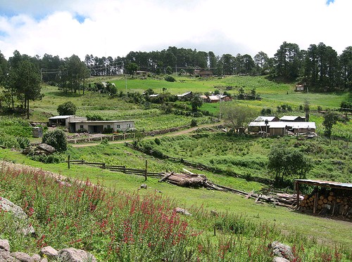
Cuajimoloyas, Oaxaca photo by Methodus Consultora S.C.
More Photos
|
Directions: From Oaxaca, go east 33km on Highway 190 to Tlacolula, then turn north and go 7km to D'az Ordaz, then turn left onto the small road and travel 28km to Cuajimoloyas. The drive takes about two hours. See More Photos.
Cuajimoloyas is known for its annual Feria de Hongos or Mushroom Festival held in late July or early August, which is near the beginning of the rainy season. The elevation of Cuajimoloyas is 3160m/10,370', and the average temperature is 48°F, so you will need warm clothing at any time of the year, and especially after dark.
See Alvin Starkman's account of his 2011 visit to the Feria de Hongos.
"There was a good visitor turnout and many mushrooms. Participants enjoyed the forest mushroom walk and conferences on bromelias, mushrooms, rural tourism, sustainable eco-alebrijes, oil of the zapote mamey and organic coffee from the Chinantla and Sierra Norte medicinal plants. The Sunday mushroom lunch buffet was a special highlight this year." [posted by Gerhard on planeta.com]
For a review of a restaurant serving wild mushrooms, see Restaurant Biznaga.
Mancomunados: This is a local organization made up of the village of Cuajimoloyas and the seven nearby towns of Benito Juarez, La Neveria, Latuvi, Llano Grande, Yavesia, Lachatao and Amatlan. The purpose of the union is the protection of the forest and of local traditions. The cultivation of a tourist industry is seen as beneficial to these goals since it provides yet another reason to preserve the forest and it gives jobs to the local youth who might otherwise be compelled to leave the villages for employment elsewhere. Tourists are attracted to the old growth pine and oak forests and the many trails which have linked the villages for centuries.

Top of page |
Hotels |
Restaurants |
Celebrations |
Transportation |
Tours |
Nearby
Hotels
• Hoteles
There is one hotel in the town of Cuajimoloyas.
- camping is available for 50 pesos per person.
- Pueblos Mancomunados, a community lodge, charges 130 pesos per person.
- Hotel Yaa-Cuetzi Also houses the tourist information office.
|
Help keep this information current. Email tom@tomzap.com with updates.
| |
Ayúdenme a mantener ésta información al día. Envía tus actualizaciones por e-mail a tom@tomzap.com.
|
Top of page |
Hotels |
Restaurants |
Celebrations |
Transportation |
Tours |
Nearby
Restaurants
• Restaurantes
There are a few restaurants around the central square in this small town. Mushrooms, which grow wild in the area, are in season during the summer.
|
Help keep this information current. Email tom@tomzap.com with updates.
| |
Ayúdenme a mantener ésta información al día. Envía tus actualizaciones por e-mail a tom@tomzap.com.
|
Top of page |
Hotels |
Restaurants |
Celebrations |
Transportation |
Tours |
Nearby
Celebrations
• Celebraciones
- Feria de Hongos Mushroom festival. Takes place annually in July and features the many mushrooms that are found growing in the surrounding forests.
|
Help keep this information current. Email tom@tomzap.com with updates.
| |
Ayúdenme a mantener ésta información al día. Envía tus actualizaciones por e-mail a tom@tomzap.com.
|
Top of page |
Hotels |
Restaurants |
Celebrations |
Transportation |
Tours |
Nearby
- Directions: From Oaxaca, go east 33km on Highway 190 to Tlacolula, then turn north and go 7km to D'az Ordaz, then turn left onto the small road and travel 28km to Cuajimoloyas. The drive takes about two hours.
Flecha del Zempoaltépetl Provides second class daily transportation between Oaxaca and Cuajimoloyas. The trip takes about 2 hours.
- Hiking The area provides numerous hiking and biking trails. There is a charge of 50 pesos for hiking. Find information at the Hotel Yaa-Cuetzi.
|
Help keep this information current. Email tom@tomzap.com with updates.
| |
Ayúdenme a mantener ésta información al día. Envía tus actualizaciones por e-mail a tom@tomzap.com.
|
Top of page |
Hotels |
Restaurants |
Celebrations |
Transportation |
Tours
Nearby
Tour Operators, Outfitters
• Operadores Turísticos, Proveedores
A 16.6km hiking trail begins at the Hotel Yaa-Cuetzi. Maximum elevation 3214 meters. The trail is part of the Pueblos Mancomunados system. There are several other trails in the area; see below. There is a fee for using the trails. www.geocities.com/sermextr/hikes/cuajimoloyas.htm
- Expediciones Sierra Norte (951) 514-8271 sierranorte@oaxaca.com
|
Help keep this information current. Email tom@tomzap.com with updates.
| |
Ayúdenme a mantener ésta información al día. Envía tus actualizaciones por e-mail a tom@tomzap.com.
|
Top of page |
Hotels |
Restaurants |
Celebrations |
Transportation |
Tours |
Nearby
Nearby Points of Interest
•
Puntos Interesantes Cercanos
- Benito Juá 6 kilometers away. A small mountain community with a botanical garden and a health clinic. A community lodge here is popular for overnight stays.
- Llano Grande Accessed from Benito Juá by a 10-kilometer trail. 4 wooden cabins for overnight stays. Served by the Cempoaltepetl bus line.
- Mirador El Calvario I 3 kilometers by trail. Passes through oyamel forest with medicinal plants and a spring.
- Mirador El Calvario II 5 kilometers by trail. Trail passes through forests with mountain views, sheep herds, and past mountain springs.
- Mirador Yaa-Cuetzi One kilometer by steep trail. Views of Pico de Orizaba, the Valley of Oaxaca, and Zempoaltépetl mountain when the skies are clear.
- Mirador Piedra Colorada 4 kilometers by trail. Forest trail to several caves and a spring.
- Mirador Xi-Nudaa 7 kilometers. Access from the road to Tarajeas.
- Tarjeas a large plain surrounded by pines located 6 kilometers from Cuajimoloyas. Accessed by hiking or bicycle.
|
Help keep this information current. Email tom@tomzap.com with updates.
| |
Ayúdenme a mantener ésta información al día. Envía tus actualizaciones por e-mail a tom@tomzap.com.
|
This page has been visited times since October 25, 2006.
| Top of page |
Main index |
Search |
What's new |
The Pacific Coast of Mexico
 www.tomzap.com
Tom Penick:
tom@tomzap.com
www.tomzap.com
Tom Penick:
tom@tomzap.com